Waddesdon Greenway (walking and cycling route)
Waddesdon Greenway is a walking and cycling route that runs between Waddesdon and Aylesbury Vale Parkway railway station.
About the route
It is:
- 3 metres wide
- set in a landscape of trees and hedges
- lit with solar stud lighting
It was introduced as part of the overall Buckinghamshire Greenway to:
- encourage more people to walk and cycle
- improve air quality
- improve public health
- reduce congestion
Read more about the route on the Greenways and Cycleroutes website.
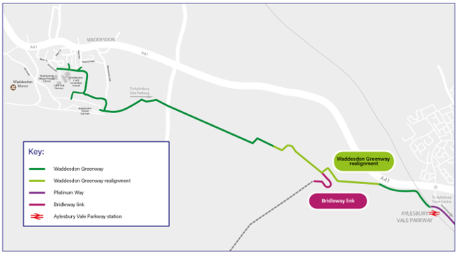
Re-routing over the HS2 railway line at Fleet Marston
A section was re-routed in Fleet Marston because it crossed over the HS2 railway line. We have built a bridge over the HS2 site so this section of the greenway is now open.
Read more about the changes in our Highways Highlight blog.
Where you can join the route
You can join it at:
- Aylesbury Vale Parkway Station
- Waddesdon Manor car park
- School Lane, Waddesdon
- Waddesdon Hill
View more about arriving at Waddesdon Manor (on foot or cycle) on their website.
Map of the route
How long it takes to travel on the greenway
The distance between Aylesbury Town Centre and the end of Waddesdon Greenway at Waddesdon Manor is 3.8 miles (6.1 kilometres).
This would take on average:
- 24 minutes to cycle
- 1 hour and 26 minutes to walk
The distance between Aylesbury Vale Parkway Station and School Lane, Waddesdon would take on average:
- 19 minutes to cycle
- 1 hour and 10 minutes to walk
Design, delivery and funding
We worked with the charity Greenways & Cycleroutes, Waddesdon Manor and other local partners.
It has been funded by:
- government grants
- contributions from developers