Improvements to the Railway Walk in Buckingham
We're proposing to upgrade Buckingham’s Railway Walk and Scenic Walk which connect Tingewick Road and the A421 along the former railway line.
The project is identified in the Buckingham Transport Strategy and Buckingham LCWIP-lite.
The changes we're proposing
The project aims to create a surfaced path that is accessible for walking, wheeling and cycling for the first time.
A new crossing point and more street lighting is proposed at Tingewick Road. And an improved crossing point is proposed at the Meadway/A421 junction, supporting onward journeys to places including:
- nearby employment sites
- nearby industrial sites
- Winslow Station (via the existing A413 walking and cycling route)
These improvements will be supported with:
- new signs
- solar studs
- accessibility enhancements (including ramps and resting points)
We're working closely with stakeholders including Buckingham Town Council and the University of Buckingham. The path will be designed to minimise impacts on the environment, recognising the path’s heritage.
How the project is being funded
We've received a grant from Active Travel England (ATE) and contributions from developers of nearby development sites (under their Section 106 obligations).
Project updates
We'll publish in-depth updates on this page as the project continues.
We updated this page in July 2026.
Proposals
The route is located along part of the old Buckingham railway line. This pathway also has access to:
- the University of Buckingham
- residential areas
- local schools
- nearby workplaces
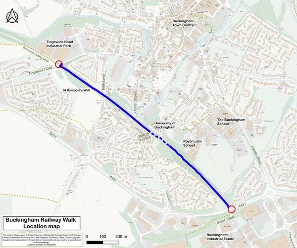
Location of the Buckingham Railway Walk
The area has a variety of wildlife and plants. However, we have opportunities to improve the route surface and improve access to (and from) the surrounding areas.
The Department for Transport recently released guidance to Local Authorities to help them design Cycle Infrastructure.
We aim to make the improvements from Autumn 2026.
We want to upgrade the route into a shared-use path that is:
- accessible for walking, wheeling and cycling
- environmentally sensitive, preserving the area’s ecology and heritage (so to minimise the impact of light pollution, we're not proposing dedicated street lighting)
The key improvements include:
- widening the path to 2.5 to 3.5 metres (view the consultation plans for details)
- improved surfacing for smoother, safer travel
- two new signalised crossings (Toucan crossings) at the A421 and Tingewick Road
- better access at the northern end including:
- a less steep ramp
- seating
- signs
- safety upgrades to increase parapet heights on the former railway bridges
- low-level solar lighting to guide users
Whilst we aim to minimise our impacts on the environment, we will remove some vegetation and small trees. This is needed to facilitate construction.
We'll also remove damaged and diseased trees that are immediately next to the path, where this is identified by our Arboricultural (Tree) Officers. This is to improve accessibility and the environment.
Phase 2
Phase 2 will focus on the section of the route owned by The University of Buckingham. This includes the former station platform and car park. Until then, this section will remain a permissive path.
Related documents
Download our documents:
- Letter to Residents and Business Owners (PDF, 230 KB)
- On - Street (Site) Notice (PDF, 162 KB)
- Arrangement Plans (PDF, 9.71 MB)
- Statement of Reasons (PDF, 114 KB)
- Newspaper Advert (PDF, 156 KB)
- (this will be published on the Bucks Herald) You can also view it on the Public Notice Portal.
- Draft Shared - Use Path Order (PDF, 947 KB)
Contact us about the improvements
You can give us your feedback on the proposals on Your Voice Bucks.
For anything else, email [email protected]