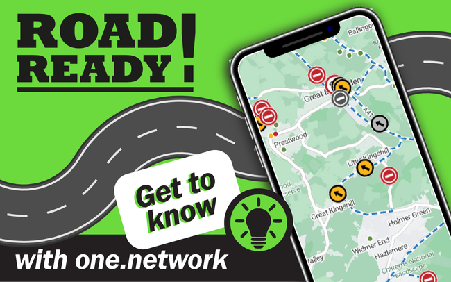
Road Ready! Getting to know One.Network
Have you ever wondered what roadworks are happening, or going to be happening within Buckinghamshire?
Welcome to our blog series helping Buckinghamshire road users get 'Road Ready' by using One.Network - a shared road management platform which connects authorities and utilities with the public, enabling safer journeys and paving the way for smart, connected mobility.
If you haven't already, take a look at how to create an account on One.Network.
With a One.Network account you can view additional information and data layers on the platform – helping you to understand what activity is taking place on the roads and how best to plan your journey. Read below for our five top tips on understanding and getting the most out of your One.Network account, helping you to be 'road ready!' in Buckinghamshire and beyond.
First things first, you'll need to let One.Network know what timeframe you would like to view. There are four default options
- Today
- Next two weeks
- Next three months
- Next twelve months
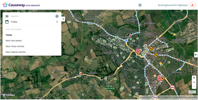
Screenshot of One.Network dashboard showing timeframe selection
Or you can customise the dates to suit your requirements by clicking on the calendar icon and using the calendar to select your start and end dates.
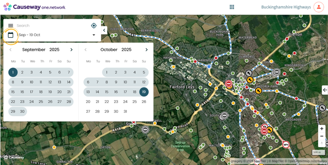
Screenshot of One.Network dashboard showing calendar customisation options
The data layers on One.Network not only allow you to see all roadworks scheduled to take place across the county, but also give you visibility of live traffic data, traffic restrictions and public events.
If you wish to only see road closures in and around an area, you will select “Road Closures and diversions”. For other traffic management, you would select "Roadworks”. The “Traffic Restrictions” layer will tell you when a road is access only or if a road is pedestrianised. The “Live Traffic” layer will show you what the traffic is currently like in real time. This can help plan your journeys and also helps the Streetworks team see if there is any build-up of traffic. If we see something suspicious happening, we will send a technician out to investigate.
To explore what can be viewed on One.Network select the three lines in the top left corner of the information box.
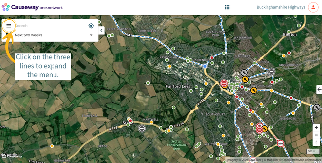
Screenshot of One.Network showing how to access the menu
Clicking on each of the data layers will open up the drop-down information and give you the option to customise your user experience by toggling certain layers on and off - depending on what you'd like to see on your map. You can even customise how you view your base map for example by illustrative roads or satellite viewing.
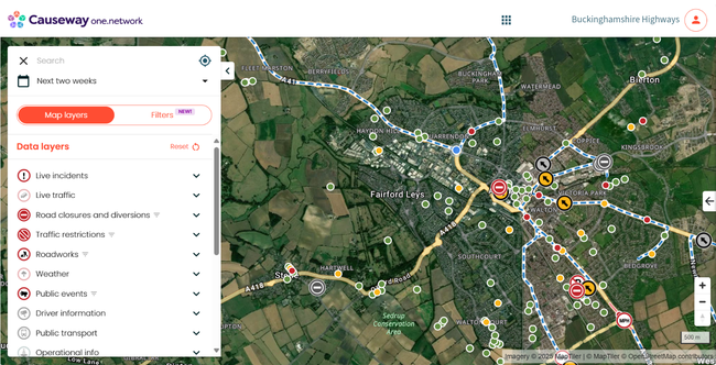
Screenshot of One.Network showing the available data layers
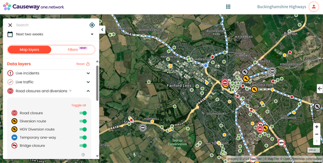
Screenshot of One.Network data layers with an expanded example
You also have the option to further filter which roadworks you would like to see on your map. You can filter based on:
- Traffic impact - a colour coded scale representing whether works are likely (red) or unlikely (green) to cause delays to road users.
- Status
- Work promoter - for example who is responsible for the roadworks
- Traffic management - the management in place for the roadworks to take place for example road closure, lane closure or traffic control signals.
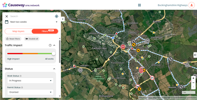
Screenshot of One.Network's available filter options
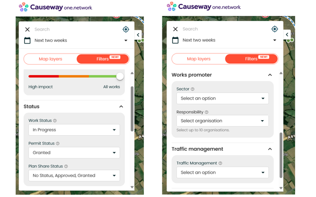
Screenshot of One.Network showing all different filter options
Once you've customised your map, set the dates and applied the data layers of interest to you, you can view all the roadworks directly on the map. Each type of roadworks is depicted by an icon to inform users what the works are related to, and are colour coded based on how likely (red) or unlikely (green) they are to impact road users and/or pedestrians. Hovering over each icon will tell you what it is representing, everything from road closures to public events, utility works to weight restrictions.
The most common icons represent general roadworks (such as road maintenance from Buckinghamshire Highways), road closures and utility works (water, gas, electricity and telecommunications). Take a look below -
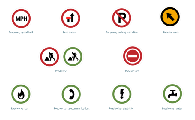
Screenshot of most common roadwork icons used on One.Network
Did you know? If you hover over a diversion route, you will be able to see where it goes and what closure it is related to. It will be highlighted and stand out more than the other diversion routes. Once you have clicked on the diversion route, this will also bring up the works tab with the information of works on.
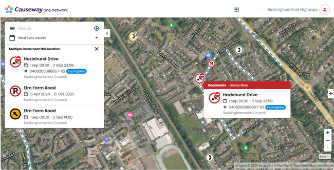
Screenshot of One.Network - an example of planned works on the map
Select a roadwork icon to find out more information about the works, and the potential impact on your journey. The information box will display all the information about the selected activity including:
- Information for road users including the location, date(s) and traffic management details
- Work descriptions detailing what is actually taking place ( for example road resurfacing) and additional location information
- Applicable permit conditions - this is where you can find specific information about what times roads may be closed to vehicular traffic and/or footways closed to pedestrians.
- Information for operational teams including the Highway Authority (that's us!), the works reference, permit reference, permit status, work status, activity type, footway closure, and whether a temporary traffic regulation order (TTRO) is required.
- Responsibility for this road event for example are these council-based highways works or works undertaken by utility companies or other work promoters.
And you can also sign up for email updates as work progresses for the specific activity!
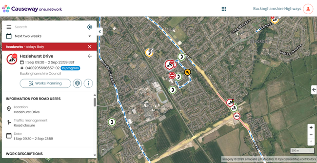
Screenshot of One.Network - an example of planned works on the map with additional detail
It is easy to help spread the word and share the full details of a roadwork activity. The three dots on the listing allow you to share specific roadwork information directly to Facebook or X, via email or by copying the URL to share with friends, family, neighbours on other digital platforms (for example WhatsApp).
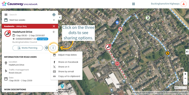
Screenshot of One.Network - options to share
So what are you waiting for? Log in to your One.Network account, view the current and upcoming roadwork activity and customise your experience to best suit you!
You can also check out how to set up alerts on One.Network.
And, if you're organising a public event, please remember to let our Highways Permits team know. This allows us to offer advice, guidance and support and plot it on our network map.