Watercourse advice note (Aylesbury Vale area)
4. Good design
Most watercourses have been altered in some way by either straightening the channel, replacing natural banks with hard engineering, dredging and widening. These changes over time have led to the loss of natural features such as bankside habitats, gravel riffles, pools and meanders, and in many cases, banks have been increased in height, disconnecting the watercourse with its floodplain.
Developments which contain or are adjacent to watercourses offer an opportunity to provide ecological buffers, restore bankside and in-stream habitats, create pond complexes and natural floodplains. Carefully designed developments along watercourses can greatly increase the ecological and biodiversity value of the features within them, and the value of the overall development.
4.1 Ecological Buffer Zones
Key principle 8: Developments shall provide a minimum 10m Ecological Buffer Zone to watercourses unless existing physical constraints prevent. A long-term landscape and ecological management plan is required for this buffer.
Development proposals adjacent to or containing a watercourse shall provide or retain an Ecological Buffer Zone (EBZ). EBZs conserve, enhance and protect the water environment. They are protective zones of vegetation which may consist of trees, wetland, scrub or grassland which offer habitat for a range of plants, animals and insects. They protect water quality by trapping sediments and breaking down pollutants before they reach the watercourse. They also offer amenity and recreation opportunities nearby, enable bank stabilisation through vegetation establishment and make space for water in a flood event and protect natural floodplains.
The effectiveness of EBZs is determined by their width and connectivity. In accordance with Local Plan Policy ‘NE2 Rivers and Stream Corridors’ the EBZ shall measure a minimum of 10m from the top of the riverbank to the development for all watercourses affected by the development. Generally, the wider the EBZ the more beneficial it is for wildlife, the exact size will depend on the site situation, what wildlife already exists at that location, how land and existing vegetation is currently managed and any links to the wider countryside or other buffer zones. Buffers that provide a natural transition between the watercourse and development, and are continuous along the length of the watercourse, are more effective than fragmented buffers.
The EBZ should be designed and managed to enhance its value for biodiversity. The development, which includes buildings, hard standing, formal footpaths, cycle paths, lighting, gardens and formal landscaping, should be located outside of the EBZ, set back from watercourse by a minimum of 10 metres. In addition to the built form, buildings should not cast shade in to the EBZ.
In accordance with Local Plan Policy ‘NE2 Rivers and Stream Corridors’ the EBZ requires a long-term Landscape and Ecological Management Plan (LEMP). EBZs can easily be delineated through the provision of open fencing separating the watercourse from adjacent land uses, particularly grazing livestock and human activities causing disturbance. Fencing needs to be open in design to allow wildlife movement and continued flow paths. Fencing of the EBZ may be needed but it is not a requirement as access can be discouraged through a planting scheme. Low bollards can be used to offer a visual separation from more heavily managed areas or when the buffer is close to a road or footpath to prevent encroachment.
More information on the management of buffer zones is provided within Section 4.1 of the Riparian Vegetation Management Good Practice Guide. See the SEPA Engineering in the Water Environment Good Practice Guide: Riparian Vegetation Management Second Edition, June 2009.

Diagram 1: Diagram showing an Ecological Buffer Zone along either side of a watercourse. The watercourse is buffered by a minimum 10 metre buffer from the top of the bank with a natural transition between the watercourse and development.
4.2 Bankside and in-stream habitats
Key principle 9: Developments should seek opportunities to re-naturalise the river channel and restore bankside and instream habitats.
Restoring meanders and enhancing straightened watercourses
Many watercourses have been historically straightened or deepened. Re-meandering straightened watercourses can increase flow diversity and provide more natural conditions and better-quality habitats for fish and invertebrates, as well as increasing water storage within the channel.
Straightened watercourse channels can also be enhanced through the creation of stone riffles and introduction of gravels to naturalise the channel.

Diagram 2: Diagram showing enhancement of a straightened watercourse channels by restoring meanders, creating stone rifles and gravels.
Revetting and supporting watercourse banks
Growth of marginal and riparian vegetation can be encouraged by re-profiling banks to be gently sloping, which will in turn provide a diversity of plants and bank stability. If a tree is identified for removal, the root system should remain intact if it is providing bank stability.
Hard bank protection such as sheet piling should be removed and replaced by soft engineering techniques such as faggoting, willow spiling and mattresses, coir matting and rolls, to enhance bank stability.
Erosion points along the bank caused by dogs entering the water can be formalised to reduce further bank erosion and sedimentation. Formalised ‘dog dips’ can be created by either using local stone or by creating ‘steps’ into the channel. Creating these features can relieve pressure from other more sensitive reaches of the bank and water access can be discouraged from other areas by making access more difficult.

Photo 5: Willow spilling is an example of a soft engineering technique to support and improve watercourse bank stability. Image: River Thame Conservation Trust.
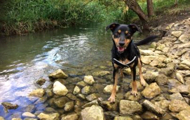
Photo 6: A formalised ‘dog dip’ created within an Aylesbury Vale area watercourse by using stone into the channel. Image: River Thame Conservation Trust.
Modifying bed levels, water levels and flows
If the channel width has been artificially increased, the creation of a two-stage channel can provide a low flow channel whilst not compromising on channel capacity and improve habitat diversity.
Consent may be required for making any changes to a main river or ordinary watercourse and advice should be sought from the Environment Agency or Lead Local Authority as to whether consent is needed for the designs proposed as described under Section 3.

Diagram 3: Diagram showing two-stage channel providing a low flow channel whilst not compromising on capacity of the channel and improving habitat diversity
Flow deflectors and berms can be used create in-stream flow and habitat variation. Existing natural features including fallen trees should be retained where possible. This can also be achieved by the installation of course or large woody debris. The Environment Agency can advise further as to whether this is desirable.
Where the natural bed has been removed by historical management and/or dredging, it can be replaced and restored. The appropriate bed substrate will depend on local conditions and area Environment Agency Fisheries, Biodiversity and Geomorphology (FBG) staff will be able to advise.
In urban areas, rivers may often have concrete banks or bed, and it is not always feasible to make space for large-scale river restoration. Reinstating some natural processes within the river channel can be the next best option. This involves introducing some form of roughness in-channel, such as woody material, reworking gravels or creating berms to create flow diversity, new habitats and areas of refuge. More information can be found in Section 3 of the RRC Manual of Techniques.
Enhancements for protected species
Creation of an artificial holt for otters: Carefully sited and constructed artificial holts may encourage otters to recolonise and breed within the watercourse, especially where watercourse management practises have been responsible for the loss of natural features. Above ground holts can also offer habitat for many different species of small mammals and invertebrates.
Creation of an artificial bank for sand martins: Sand martins nest colonially usually in the sheer faces that develop naturally on river meanders. Bedding 1m lengths of 4-10cm polythene pipe into a bank constructed from sand and gravel can create safe and long-lasting artificial sites. The lowest row of pipes should be 1m above summer water level, sloping slightly down towards the entrance, with rows 0.3m apart and pipes at 0.2m spacings.
Creation of an artificial bank/nest site for kingfishers: Kingfishers breed beside still or slow flowing freshwater, typically nesting within a vertical or steep earth bank at or very close to the water’s edge. Where no suitable natural bank exists an artificial one can be created and/or artificial nest boxes installed. The nest box entrance must be at least 1 metre above the maximum water level and should be completely buried so that only the nest entrance is visible. The tunnel should slope down from the nest at an angle of 10 or 20 degrees for drainage, with a layer of dry soil placed in the nest chamber and a small nest cup made to keep the eggs together.
4.3 Culverts, crossings and barriers
Key principle 10: Developments must not involve the culverting of watercourses and should actively pursue de-culverting opportunities.
Culverts
Culverts are artificial water channels. They vary considerably from narrow pipes through to large-square sided channels which encase a watercourse underground. Culverting watercourses leads to the loss or damage of plants, animals and their habitats, and creates a barrier to the movement of fish and other wildlife. Culverts increases flood risk due to the risk of blockages. They can also complicate maintenance due to small spaces and items becoming tangled in trash screens.
Where culverting of a watercourse or channel diversion is both necessary and the only reasonable and practicable alternative the development will need to demonstrate that it will not have a detrimental effect on flood risk and the habitat(s) and species present, or that mitigation measures can be put in place to reduce these effects. The Permit issuing organisation should be consulted at the earliest opportunity so that advice can be provided (see Section 3 ‘Permits and Consents’). It should be noted that the development will be required to show no net loss of channel length or ecological value. Also see the Council’s culvert policy (2019).
Alternatives including crossings
In accordance with Local Plan Policy ‘NE2 Rivers and Stream Corridors’ culverting of watercourses must be avoided and opportunities to de-culvert watercourses sought. Alternatives to culverts include using clear span crossings, constructing parts of the development elsewhere and as a last resort, diverting the watercourse elsewhere.
- Crossings should be clear span in design with abutments set back from the top of the bank to enable bank habitat to be maintained. There should be no in-stream supports within the watercourse channel in order to maintain the natural riverbed – in-stream supports are only appropriate where they are necessary to ensure structural integrity (ie very wide rivers).
- Crossings should be located perpendicular to a watercourse, on a straight stable section where there is no evidence of active erosion or deposition.
- Any raised surfaces created to reach the bridge should be made from natural materials, be short in length and have a natural surface.
- For footbridge or cycleway crossings, fencing may be required to stop a pinch point of dog activity at the bridge.
- Fords should not be created and where these occur within a development boundary, the banks should be repaired and a formal crossing installed as fords lead to river-widening, increased risk of pollution, bed and bank erosion.
- For larger crossings, ledges (approximately 500mm wide, 300mm above the normal water level, with minimum 600mm headroom) are required to allow for the passage of mammals. These should link to the banks upstream and downstream of the crossing. These structures can also incorporate features to encourage bat roosting and bird nesting as appropriate. More information is provided within the Standards for Highways Works' Design Manual for Roads and Bridges LD 118 - Biodiversity design (2020 update).
De-culverting opportunities
Restoring culverted watercourses can provide valuable wetland/aquatic habitats, offers amenity and recreation opportunities, reduces maintenance and construction costs, reduces flood risk and gives a place a sense of identity.
For large culverts with no adjacent development the watercourse should be returned to a more naturally functioning form. For channel/box culverts with adjacent development the culvert should be opened, and the bed returned to a natural state. Where this is not possible, enhancement or mitigation work should be implemented elsewhere on the watercourse.
4.4 Ponds
Key principle 11: Developments providing pond complexes to achieve biodiversity net gain or enhancements or that are creating sustainable drainage systems should utilise best practice guidance (The Pond Creation Toolkit).
Ponds are a critical habitat for freshwater plants and animals and are often the source of the cleanest water. To create clean water ponds, find a place with a clean water source, leave the pond to colonise naturally and make sure the pond is protected from damaging impacts during its lifetime.
Pond design is important to maximise biodiversity benefit as follows:
- create pond complexes or multiple pools including both permanent and seasonal ponds of varying areas and depths, rather than a single waterbody.
- make broad, undulating drawdown zones
- make sure that most pond slopes are shallow (less than 1:5)
- create underwater bars and shoals to benefit aquatic plants
- design according to your landuse and site management (eg grazed or ungrazed meadow) and think about how the site will develop in the longer term
- use design to minimise future problems – think about how the pond will be used by people and animals
For more information on how to design high-quality wildlife pond complexes refer to and follow the Freshwater Habitats Trust Pond Creation Tool Kit.

Diagram 4: Example of good pond complex design with varying areas and depths. A large deep pond and shallower ponds are created. Small seasonal ponds are also present within wetland areas. Diagram adaptation from Freshwater Habitats Trust Pond Creation Tool Kit.
4.5 Floodplain reconnection and wetlands
Key principle 12: Developments should reconnect rivers with their floodplains and where biodiversity net gains or enhancement is required, create habitats such as wetlands, scrapes and backwaters Naturally functioning floodplains can be hugely diverse and can support an array of different habitat types such as wet grassland/meadows, wetlands and wet woodlands. Rivers have been disconnected from their floodplains due to agricultural intensification and urban development and as a result these floodplain habitats are now very rare in lowland areas (see Stephen Addy et al, (2016) River Restoration and Biodiversity: Nature-based solutions for restoring rivers in the UK and Republic of Ireland).
The restoration or creation of floodplain habitats can have huge biodiversity benefits as well as naturally reduce flood risk (Box 4).
Wetlands
Wetlands such as fen, carr (wet woodland), marsh, swamp and reedbeds develop anywhere where water remains at or near the surface year-round. A wetland meadow does not have standing water except for a few brief periods during the growing season. These habitats can be found on river floodplains and vary in character depending on the type of flooding, source of water and land management.
The floodplain can be reconnected by removing or lowering river embankments to reconnect with the river channel. Wetlands are created when an area of the floodplain as it is allowed to flood or deliberately flooded for flood management purposes.
Changing land use can improve soil infiltration and reduce surface run-off, for example through arable reversion to grassland, or re-forestation of the floodplain and woodland creation.
Scrapes
Scrapes are shallow depressions (c. 30cm below and 10cm above normal water levels) with gently sloping edges which seasonally hold water (between March through to the end of June) which are ideally located within large, open, lower lying areas such as flood plains. They can be either be non-connected or connected to a water source such as a ditch, spring or watercourse. Once created open muddy margins should be maintained either by extensive livestock grazing/poaching or annual mowing.
Scrapes support a wide variety of wetland invertebrates and provide feeding areas for wading birds, such as snipe and lapwing, and their chicks. The scrapes offer additional floodwater storage within the floodplain.
For more information on how to design scrapes refer to and follow the RSPB Scrape Creation for Wildlife guidelines or contact the RSBP online.
Backwaters
Backwaters are wet areas that are connected to the main river channel but with little or no flow. They may be seasonally or permanently inundated. The backwaters offer below surface level flood storage and are connected to the river by a low bund or overflow pipe. Redundant river channels can be enhanced by backwater creation.
Backwaters provide important habitat for a range of aquatic flora and fauna including invertebrates and fish. The warmer conditions and shallow refugia are ideal areas for juvenile fish during times of flood and invertebrates, such as dragonflies and damselflies, which rely on still unpolluted waters.

Photo 7: A newly established backwater connected to the main river channel providing new habitat for invertebrates and fish. Image: River Thame Conservation Trust.
Natural flood management
Natural flood management (NFM) is the alteration or restoration of natural processes to reduce flood risk. An example of such a scheme is at Leckhamptead, Bucks. Floodplains are essential components of a river corridor, and their natural role is to store and slow down flood water. Floodplain restoration is an example of NFM and can increase flood water storage and reduce flooding downstream, whilst supporting a unique community of plants and insects. Further guidance on NFM is provided within The Natural Flood Management Toolbox documents.
4.6 Sustainable drainage systems
Sustainable Drainage Systems (SuDS) are used as an alternative to conventional ways of managing surface water. The main purpose of SuDS is to mimic the natural drainage of the site before development. This is achieved by capturing rainfall and allowing as much as possible to evaporate or soak into the ground close to where it fell or through designed storage areas. The rest is directed to the nearest watercourse to be released at the same rate and volumes as before development.
SuDS can provide some natural removal of pollutants and sediments, as well as promoting aquifer recharge and enhancing biodiversity, which all provide environmental benefits. They can also be designed to add aesthetic value and offer attractive natural amenities for the local community.
If the SuDS is within a river corridor then refer to Adopted Vale of Aylesbury Local Plan Policy NE2 (see Appendix 1) and Buckinghamshire Council SUDS developer pack.
The drainage aspects of a planning application will be considered by the SuDS team at the Lead Local Flood Authority (Buckinghamshire Council) as part of their statutory duties.
Pre-application advice prior to submitting a planning application is encouraged. Early engagement ensures the full benefits of sustainable drainage systems are recognised on developments. More information on the SuDS Pre-application advice service is provided by the LLFA.
Further guidance on sustainable drainage is provided within the CIRIA Guidance on the construction of SuDS document.
4.7 Public access
Many riverside areas are currently inaccessible to the public because they fall within private ownership. In-line with the Aylesbury Vale Green Infrastructure Strategy and Local Plan Policy ‘I1’, the Council expect opportunities for increasing appropriate informal public access to rivers to be taken, providing that this would not result in conflicts with other Local Plan Policies and key interests such as the value of that habitat for conservation purposes.